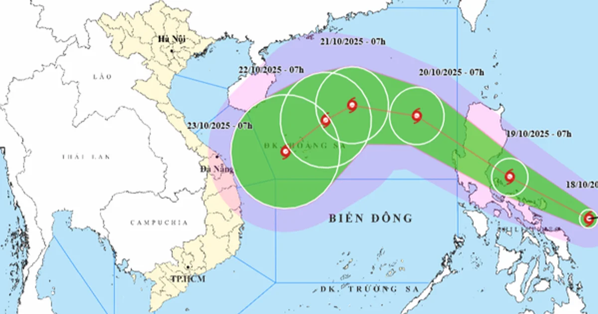
Storm Fengshen is advancing westward from the central Philippines into the East Vietnam Sea, posing heightened risks for maritime operations across the region. As of 7:00 am on October 18, 2025, the National Center for Hydro-Meteorological Forecasting reported the storm’s central position over the eastern waters of the Philippines, registering maximum sustained winds of 62 to 74 kilometers per hour (kph) and gusts peaking between 89 and 102 kph. Fengshen is currently moving at an approximate speed of 20 kph and is projected to intensify further in the coming hours.
Beginning on Sunday, the northeastern section of the East Vietnam Sea is expected to experience strong winds ranging from 39 to 88 kph, with gusts climbing to 103–117 kph. Wave heights in this area could reach significant levels of 2.5 to 5 meters, creating hazardous conditions for vessels navigating the waters. By Monday through Wednesday, the northern region of the East Vietnam Sea, including Vietnam’s Hoang Sa (Paracel) Special Zone, is forecast to endure wind speeds between 89 and 117 kph, alongside gusts reaching 134–149 kph. This period is anticipated to be particularly dangerous for maritime and coastal activities.
The national weather agency has issued advisories for ships operating within the predicted storm zones, warning of severe thunderstorms, strong winds, and high waves. The storm’s trajectory is predicted to initially move northwest upon entering the East Vietnam Sea but could shift abruptly southward under the influence of a northeast monsoon. Meteorologists also cautioned that the interaction between Fengshen and a cold air mass could result in volatile and extreme weather conditions, underscoring the need for constant surveillance and precautionary measures.
Officials are urging vessels to heed safety warnings, avoid risky sailings in affected zones, and maintain open communication with port authorities. The unpredictable nature of Fengshen’s development and track presents elevated challenges for maritime operators throughout the impacted regions.
Why this matters
The escalation of Storm Fengshen brings immediate concerns for shipping operations within the East Vietnam Sea, a vital corridor for regional trade. With sustained winds exceeding 100 kph and wave heights reaching up to 5 meters, storm-induced disruptions could severely hamper vessel schedules, delay cargo deliveries, and increase risks for maritime crews. Operators of bulk carriers and tankers transiting the northern section of the sea may face heightened exposure to safety hazards.
Additionally, the storm’s erratic trajectory and interaction with monsoonal patterns complicate navigational planning, requiring vessel masters and shore-based operators to frequently revise routes and contingency measures. The potential for intensified weather conditions underscores the importance of investing in robust storm tracking systems and ensuring compliance with regional port authority directives for early safety evacuations.
The influence of Fengshen on operational maritime activity will likely depend on the storm’s evolving path and interaction with prevailing monsoons. Seafarers and freight operators should remain alert to advisory updates and prepare for possible delays and rerouting in the event of further intensification or unexpected movement within the East Vietnam Sea. Continuous monitoring of weather developments remains critical.